Ireland boasts 13 delectable Furth Munros - a Furth being a mountain outside, or ‘furth’ Scotland but high enough to have been a proper Munro were it lucky enough to reside within Scotland. See Dave Hewitt’s account of the history of this term here; broad discussion here.
Based on my visit earlier this week, this post aims to help the Furth-bagger with the summary logistics, a taste of the routes, and pointers to detailed route descriptions as they are not included here.
My favourite Irish Furths are Brandon Mountain with its commanding views over the sinuous and convoluted coastline of Dingle; and the 10 summits spiking along the sometimes knife-edged ridgeline of Macgillycuddy’s Reeks (a ridge that invites you to risk traversing its full length in one go despite the fact that the preferred 10 hours of visibility does not fit into the 8 hours of sun up in early winter).
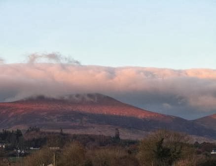
The Faha Ridge en route to Brandon Mountain:

Overview
Ireland’s highest mountains lie to the south of the country,
and are mainly of sandstone though the Wicklow Mountains including Lugnaquilla
are of volcanic origin.
All these mountains were born of immense and varied
geological forces. About 420 million years ago, tectonic movements had caused the collision of the Laurentian and Avalonian plates bearing the originally separate northern and southern parts
of Ireland [see the animation here].
The intervening Iapetus Ocean was eventually squashed shut; and into the
resulting basin rivers deposited rock / sand [375 m yago].

The friction of such seismic events caused deep-seated magma
to well up in volcanic hot-spots to create mountain ranges such as the Wicklow
Mountains including Lugnaquilla. These latter mountains are thus mainly of
granite, albeit with remnants of the rocks that had originally covered them. Of
course, like mountains everywhere, most of the dramatic features have been dug
by fault-lines and then carved more recently [in the last 1.7 m years] by the
abrasion of ice, the gnawing of Ice Age freeze-thaw, and the drip-drip erosion
by rain.
Quick itinerary for
the visitor to Ireland
Four stops on a simple loop from Dublin means that you can
climb the Furth Munros in four or possibly five days. Or you could of course combine
these climbs with broader adventures on other beautiful mountains in Ireland.
Our itinerary was
Day 0 Arrive Dublin. Drive to Wicklow National Park (1 hour)
Day 1 Climb Lungaquilla; drive to Castlegregory (4 hours)
Day 2 Climb Brandon Mountain via the Faha Ridge; drive to
Cronin’s Yard (1 hour)
Day3 Climb the Western Reeks via x Coumloughra Horseshoe
Day 4 Climb the Eastern Reeks descending via the zig-zags; drive
to Cahir (2 hours)
Day 5 Climb Galtymore; return to Dublin (2 hours)
Fit parties can combine the Eastern and Western Reeks into a
single long day, as was evidenced even on our winter visit by the descent of several
noisy climbers into Cronin’s Yard at 2am, their way lit by headlights. But then
you miss the views…
Lugnaquilla (Log
na Coille, meaning "hollow of the wood")
Wicklow National Park allows camping. Emerging from our tents
near the secluded Boravore car park at T066942, we hailed and then latched on
to a party of other walkers. John, their leader, had climbed this mountain more
than 100 times (!) and we followed his confident lead up a steep and
occasionally completely overgrown path, heading westwards and immediately
uphill from the car park.
Having climbed a deep gully, we reached rolling pathless
moorland, a flattish green plateau, and then a curve southwards to approach the
summit at T032917. The summit perches between two glacial corries (the North
and South Prisons; be careful as the former is a military firing range). Alas
the mists descended, so the reputed views across the Irish Sea to Snowdonia
remained hidden.
We retuned via Art’s Lough and the track that returned to
the car park (and by which less adventurous walkers may approach the summit).
13km; 900m guidebooks suggest 5 hours; we took 3:45 hours.
All timings exclude breaks. There are many other routes up this hill.
The palatial cairn atop Lugnaquilla:

Brandon Mountain (Saint Brendan’s Mountain)
We overnighted at Castlegregory (and the beautiful Dingle
peninsula offers many a B&B) then started from the car park (Q493 119) just
past Cloghane. There is a lower Pilgrim’s Path that enters the corrie then
claws its way to the summit at Q460116 so that pilgrims can pay homage to Saint
Brendan who, according to texts of circa 900AD, crossed to North America in a
coracle four hundred years earlier.[He may in fact have reached Iceland.].
We, however, opted for the more exhilarating Faha Ridge. To
quote summitpost.org: “… quite suddenly, the walker comes to the end of the
rock plateau (third notch) and is faced with a sheer drop of perhaps 10-15
metres down to the saddle… Any evidence
of a path seems to disappear at the edge of the drop, and it takes a few
minutes examination before a possible route down a rock chimney is found to the
right with, if recent, the occasional mark of a boot on the small ledges half
way down. This is perhaps the best scrambling on the route, and both hands and
feet are needed to obtain the bottom. .. Once at the saddle, you leave the rock
wall you’ve just come down, but are faced with an altogether more formidable
wall looming above you.”
The summit bears a cross and offers panoramic views over the
fractal coastline of Dingle and is reputedly the last spot in the British Isles
to be illuminated by the setting sun.
There are several routes of ascent and descent; we chose to descend
by circling southwards via the “fangs” ridge that includes Brandon South Top
and Brandon Peak , before dropping to meet a track that runs back towards
Cloghane; a short-cut limits the road walking to 5 km.
13km 1,000m ascent; guidebooks suggest 5:30 hours; we took 5
hours
Brandon Mountain:

Macgillycuddy Reeks (West)
The Coumloughra Horseshoe
(Reek=stack; Macgillycuddy = local landowners)
Preferring the beauty of full daylight views of the Reeks rather
than the bravura of a single traverse of the full range that would have been
partly in the dark at this time of year, we decided to walk the range in two
parts. We had stayed at Cronin’s Yard, the 200-year old base from which to
climb Ireland’s highest peaks. It’s worth a Google.
The western horseshoe is a well-known classic route that
takes in Ireland’s Mount Everest, K2 and Kanchenjunga – together with the
‘interesting’ Beenkeragh ridge.
We started from the new car park – which may not appear in
reports older than 2011 – at approximately V771 873, then SE up the concrete ‘Hydro
Road’ that lets you gain altitude quickly. Our route was clockwise though others
on this day went the other way and there seems little to choose between the two
directions.
From a wee lochan we gained the ridge which affords continuous
views down to the joined ‘Siamese loughs’ beneath. The going was not too hard
at first, and Caher West Top [the 5th highest mountain in Ireland], Caher
[#3], and Carrauntoohil [#1] were easily attained. The crossing to Beekeragh is
more risky and it’s worth taking detailed instructions with you. We were
clambering on narrow ledges, holding on tightly, stepping down carefully lest footings
should give way, and glad to have printed directions when too many options, all
equally enticing, beckoned us onwards. We took great care across The Bones [#7]
aka Carrauntoohil Tooth and unsure which was its true needle to be climbed,
climbed all candidates before eventually reaching Breekeragh [#2]. Relative safety
prevailed thereafter as we looped back down the wee lochan, glancing
periodically back at the stunning ridges, peaks, and surrounding lands.
13.3km; 1,420 m ascent; guidebooks suggest 6 hours; we took
5 hours

Macgillycuddy Reeks (East)
From Cronin’s Yard we headed up the track towards the Reeks,
cutting left to traverse virgin moorland, pulled on by the just-visible grotto atop
Cruach Mhor. We rounded the Lake of the Serpents, and reached the grotto with its
Madonna. In the cold and mist now, we
continued on along the rocky ridge with towers to be negotiated by hard-ish scrambling
to the pinnacle that is the Big Gun. The rocky spine continued to Cnoc na Peiste,
but the route eased thereafter to Maolan Bui, and Cnoc an Chuillin.
Evocative names loomed ahead. We declined the heavily eroded
Devil’s Ladder in favour of the Zig-Zags, to reach Hag’s Glen and then passed beneath
the Heavenly Gates to reach the Yard again.
12km; 1,300m ascent; guidebooks suggest 6:30; we took 5
hours
The Grotto:


Galtymore (Big
hill of the Galtees [Galtee perhaps coming from Coillte = forests])
The Galtee range rises steeply from the surrounding plain,
its highest mountain a Munro by just 15 feet.
We left the accommodation at Cahir early and started our
climb from the top end of the Black Road, which leaves the R639 just east of
the village melodically-named Skeheenaranky.
Not wishing to miss our travel connections, we covered the 9.6
km and 650 metres of ascent in 2 hours 15 minutes thanks to the track that
leads 75% of the way to the summit, and despite the peat hags, which were
relatively dry. We did have time, however, peer several times down the mountain’s
sheer north face and into the corrie beneath. Allow three hours on this route
if you are not in a hurry, but there are other longer routes to be found.
Though ‘a quickie’, Galtymore
provides great views when the weather allows, both from its summit, and from
the lower plain on which its stands proudly facing of Knockmealdown which is
100 metres shorter but does not look it.
Galtymore:
We found the guidebook useful: The Dingle, Iveragh & Beara peninsulas: A Walking Guide by Adrian Hendroff.
____________________________
The weather had blessed us by remaining dry for our five day
sortie, and in the words of the Irish blessing we had found that ...
The road had risen up to meet us
The wind had been always at our backs and
The sun had been on our faces (well occasionally!)
No comments:
Post a Comment